Share :


Share :
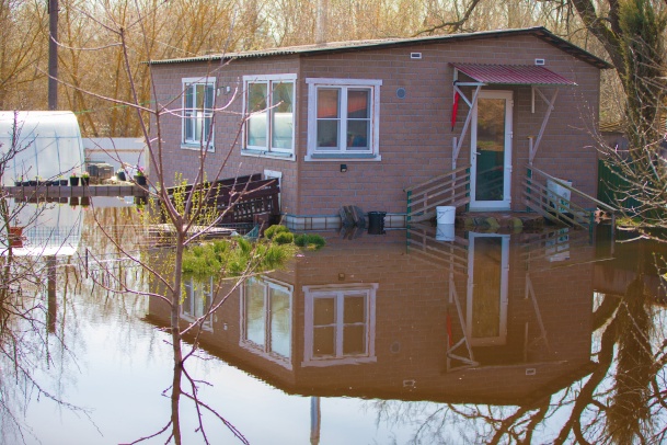
In an era where once-in-a-century storms seem to occur every few years, Canadian homeowners are facing a hidden threat: outdated flood maps.
The Insurance Bureau of Canada (IBC) has stressed the importance of transparent flood mapping for both homeowners and insurers. Clear, accurate maps allow insurers to price policies fairly, encourage property-level mitigation, and support investment in community resilience.
As climate change accelerates extreme weather events, the data used to assess your home’s risk and determine your insurance premiums often lags decades behind. Recent mapping updates in Quebec highlight this issue, and the lack of national data is contributing to the flood risk gap, a significant concern for both the insurance industry and property owners.
Here’s what you need to know about the current state of flood mapping in Canada and how it affects your home insurance.
A flood map is an essential tool that identifies areas at risk of flooding by analyzing factors like topography and historical weather data. These digital maps aid in risk assessment and land-use planning by highlighting vulnerable regions to various types of flooding.
The process of creating a flood hazard map involves several steps, including prioritizing high-risk areas, gathering crucial meteorological and elevation data, and assessing past data to predict future risks. The process includes identifying flood risk zones, recommending land-use restrictions, and engaging the community to ensure effectiveness.
Using flood maps helps build safer, better-prepared communities and enables insurers to provide accurate coverage quotes.
Most basic home insurance excludes overland flooding, the most common climate threat in Canada. Ensure your home is protected with the right water and sewer backup endorsements before the maps change and premiums rise.

Despite the serious implications of this situation, Canada remains the only G7 nation without publicly available national flood maps. This absence of transparency leads to several issues:
A study by a group at the University of Waterloo on climate risk confirms that about 10% of Canadian homes account for over 90% of flood-related losses. Without accurate flood maps, insurers may receive unexpected claims and struggle to develop coverage that truly reflects the associated risks. Public Safety Canada indicates that 1.5 million households are at high risk of flooding.
Delays or politicization in mapping can create uncertainty, leading to coverage gaps, increased premiums, or insurers withdrawing from high-risk areas. This restricts access to mortgages and financial services, worsening the financial and social impacts of floods. Outdated or incomplete flood maps contribute to insurer uncertainty, which carries substantial financial consequences for individuals and communities.
Here are four reasons how this uncertainty can impact your finances:
Understanding these implications is essential for homeowners and community planners as they navigate the complexities of flood risk management and insurance coverage.
You don’t have to wait for a map update to safeguard your property. Flood risk is a community-wide issue; when a neighbour paves over green space or a new development changes local drainage, water flow patterns shift. Protecting your home means looking upstream to see where water comes from and downstream to ensure your diverted water doesn't create a disaster for someone else.
Here are three ways to take control of your flood protection today:
Here is a practical, 5-minute checklist to help you identify potential flood vulnerabilities around your home. Addressing these small details can often lead to lower premiums or better eligibility for coverage.
Exterior: the water flow walkthroughIf you are looking for your local flood plain map, there are a few resources:
Not necessarily, but your coverage will likely become more expensive or restricted. Most standard Canadian policies treat overland flood coverage as an optional add-on rather than a guarantee. If new mapping identifies your area as high-risk, your insurer might increase your premiums, reduce your coverage limits, or require you to install mitigation measures, such as backwater valves or a sump pump, to remain eligible.
If private insurance becomes unavailable, you may need to look into the federal high-risk insurance flood program currently being implemented for homeowners in uninsurable zones.
Government maps often focus on rivers overflowing, but insurers also look at urban flooding (heavy rain on pavement) and sewer backups. Even if you aren't near a river, your premium may stay high due to outdated city drainage, local construction that prevents water absorption, or modern climate models that predict more frequent extreme storms for your specific postal code.
Accurate flood maps are essential for public safety and the stability of the insurance market. They help insurers assess risk, enable homeowners to take protective measures, and assist governments in allocating resources for flood prevention.
As extreme weather events become more frequent, Canada must update its flood maps. This modernization will impact the availability, affordability, and reliability of flood insurance, making timely updates a top priority.
Want to ensure your home is protected against the next big storm? Get a home insurance quote online or call us today to speak with one of our licensed advisors.
Share
Digital Content Writer
Kayla-Jane has been a content writer with ThinkInsure since 2020. She creates insurance content for auto, home, and commercial. Kayla-Jane has a diploma in Journalism.
| Categories | Home |
|---|---|
| Tags | Protect Your HomeHome Coverage |
Read our insurance blog to get helpful tips, information and news.

Learn how car insurance deductibles work in Ontario. Discover how choosing a $500 vs. $1000 deductible impacts your auto insurance premiums and claim payouts.

The Statutory Accident Benefits Schedule in Ontario ensures certain benefits are available to any person injured in a car accident. In this blog, we’ll discuss what the statutory accident benefits schedule is and the role it plays in insurance and accident benefits claims.

Accumulated a few demerit points on your driving record? Here are some of the most common questions about demerit points in Ontario, how the demerit points system works, and if they can impact insurance.

There are situations where you will want or be required to have additional insurance, often in the form of optional enhancements called the Ontario Policy Change Form (OPCF).
